
The Central Meteorological Observatory issued a typhoon orange warning at 6:00 on the 16th:
The 13th strong tropical storm "Qi De" was strengthened into a typhoon in the northern part of the South China Sea at 05:00 on the 16th. At 0500, its center is located on the sea surface 870 kilometers south of Zhanjiang City, Guangdong Province, which is 18.7 degrees north latitude and 118.2 degrees east longitude. The maximum wind pressure near the center is 12 (33 m / s), the lowest pressure in the center is 975 hectopascals. 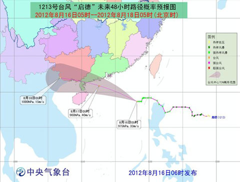
"Qingde"'s future 48-hour path probability forecast map predicts that "Qingde" will move to the north-north direction at a speed of 20-25 kilometers per hour, and gradually approach the coastal area of ​​Zhuhai to Xuwen, Guangdong, and the intensity will continue to strengthen. On the morning of the 17th to noon landing in this area along the coast. 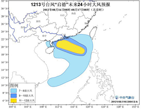
The "24-year-old" wind forecast map of "Qingde" is affected by the "Qingde" and the southwest monsoon. From 08:00 to 17:00 on the 16th, the Bashi Channel, the Balintang Strait, the Taiwan Strait, the north-central South China Sea, the Guangdong Coast and There will be 7-9 winds in the Pearl River Estuary, the eastern and northern coasts of Hainan, the Qiongzhou Strait and the eastern part of the Beibu Gulf. The winds in some sea areas or regions can reach 10-11. The winds in the nearby sea areas or areas of the Kai Tak Center are At 12-13, the gusts can reach 14-15; there are heavy rains in southern Fujian, most of Guangdong, southwestern Guangxi, and northern Hainan. Among them, there are heavy rains in parts of southern Guangdong and northeastern Hainan, and the southern coast of Guangdong. The area has a heavy rain (250-300 mm). 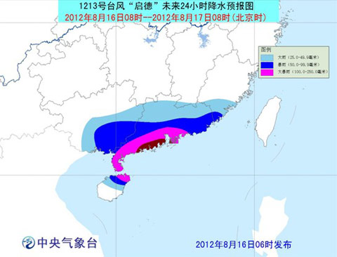
"Qingde" future 24-hour precipitation forecast map defense guide:
1. The government and relevant departments shall, in accordance with their duties, do a good job in preventing typhoon emergency response;
2. Water operations in the relevant waters and passing ships should return to Hong Kong to avoid wind, strengthen port facilities, and prevent ships from anchoring, stranding and collision;
3 Stop indoor and outdoor large gatherings and outdoor dangerous work such as high altitude;
4. Reinforce or dismantle the members of the building that are easily blown by the wind. Do not go out at will. Try to stay in a place where wind and safety are safe, and ensure that the elderly and children stay in the safest place at home. When the typhoon center passes, the wind will decrease or stay for a while. Remember that the strong wind will suddenly hit, and should stay in the safe place to avoid the wind, and the dangerous people will be transferred in time.
5. Relevant areas should pay attention to prevent mountain floods and geological disasters caused by heavy precipitation.
Concrete Saw Blade,Concrete Cutting Blade,Diamond Cutter Blade
Sintered Saw Blade Co., Ltd. , http://www.nsdiamondtool.com